|
|
Runyan Lake Inc.
The lake association for the entire community
of Runyan Lake
|
|
|
|
|
Runyan Lake Water Level Control
Did you know the water level for Runyan Lake is managed by a level control device? The legal level of Runyan Lake was established by court order in 1964 as 894.0 feet by means of the Inland Lake Level Act, Michigan Public Act 146 of 1961. The current dam and spillway was constructed in 1965.
The Livingston County Drain Commission is responsible for inspecting and maintaining the device which controls the water level of Runyan Lake. This action is authorized by Part 307 of Michigan Public Act 451 of 1994. The level control device, an artificial barrier used to regulate the level of the lake, is often referred to as a weir. More commonly, it is simply referred to as the "outlet".
Special assessment district: Established in 1940, Runyan Lake waterfront properties are incorporated into a special assessment district to recover the costs associated with inspecting and maintaining the water level control device. The Livingston County Drain Commission recovers these costs about every three (3) years by means of a special assessment included in our individual winter tax bills. You will see this itemized as "Runyan Lake level control". Because the cost during recent years has been limited to inspection only, the drain commissioner has elected to save residents the administrative costs associated with annual special assessments and instead defers the costs until such time as it is reasonable and necessary to require payment for the services rendered.
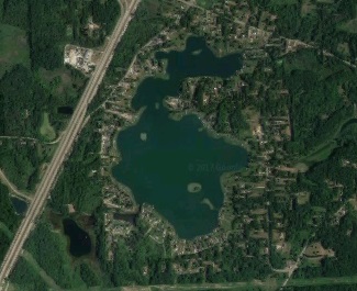
Waters Affecting the Level of Runyan Lake: Runyan Lake is a spring fed lake with additional inflows from several creeks, and of course the watershed area. The creeks are located around the lake, the largest being Denton Creek found at the north end (water originates from Sullivan Lake, which flows into Goodfellow and additional smaller lakes to the north before entering Runyan Lake), with smaller creeks being located near the southwest, south, east, and Runyan Lake Cove portions of the lake. The single outlet is located in the northwest portion of the lake and is named Runyan Creek. Runyan Creek waters flow into a wetland area beside US-23 at White Lake Road, then under US-23 to Sterns Lake, to the Preserve wetlands area, then to Hoisington Lake, Bennett Lake, and on to Lobdell Lake.
Effect on Aquatic Weed Control Efforts: The Michigan DEQ limits or prohibits the application of chemicals within 750 feet of the outlet after June 1. Prior to June 1 this exclusion zone is 1000 feet. Members whose properties are within this zone are afforded aquatic weed control only by virtue of the travel of any chemicals applied elsewhere as they progress towards the outlet. Unfortunately, the chemical treatments are generally diluted to the point of being ineffective by the time they reach this area.
Reference Materials:
|
|
Runyan Lake Inc. PO Box 105 Fenton, MI 48430-0105, USA
Reproduction in whole or in part in any form or medium without express written permission from Runyan Lake Inc. is prohibited. Please view our: | Privacy Policy | Terms of Use | Site Map |
|